The Blue Marble, a photograph of the planet Earth made on 7 December 1972 by the crew of the Apollo 17 spacecraft.
The world is the totality of entities, the whole of reality, or everything that exists. The nature of the world has been conceptualized differently in different fields. Some conceptions see the world as unique while others talk of a "plurality of worlds". Some treat the world as one simple object while others analyze the world as a complex made up of parts.
In scientific cosmology, the world or universe is commonly defined as "[t]he totality of all space and time; all that is, has been, and will be". Theories of modality talk of possible worlds as complete and consistent ways how things could have been. Phenomenology, starting from the horizon of co-given objects present in the periphery of every experience, defines the world as the biggest horizon or the "horizon of all horizons". In philosophy of mind, the world is contrasted with the mind as that which is represented by the mind. Theology conceptualizes the world in relation to God, for example, as God's creation, as identical to God or as the two being interdependent. In religions, there is a tendency to downgrade the material or sensory world in favor of a spiritual world to be sought through religious practice. A comprehensive representation of the world and our place in it, as is found in religions, is known as a worldview. Cosmogony is the field that studies the origin or creation of the world while eschatology refers to the science or doctrine of the last things or of the end of the world.
The UNGA is responsible for the UN budget, appointing the non-permanent members to the Security Council, appointing the UN secretary-general, receiving reports from other parts of the UN system, and making recommendations through resolutions. It also establishes numerous to advance or assist in its broad mandate. The UNGA is the only UN organ where all member states have equal representation. (Full article...)
The origins of the Internet date back to research to enable time-sharing of computer resources and the development of packet switching in the 1960s. The set of rules (communication protocols) to enable internetworking on the Internet arose from research and development commissioned in the 1970s by the Defense Advanced Research Projects Agency (DARPA) of the United States Department of Defense in collaboration with universities and researchers across the United States and in the United Kingdom and France. The ARPANET initially served as a backbone for the interconnection of regional academic and military networks in the United States to enable resource sharing. The funding of the National Science Foundation Network as a new backbone in the 1980s, as well as private funding for other commercial extensions, encouraged worldwide participation in the development of new networking technologies and the merger of many networks using DARPA's Internet protocol suite. The linking of commercial networks and enterprises by the early 1990s, as well as the advent of the World Wide Web, marked the beginning of the transition to the modern Internet, and generated a sustained exponential growth as generations of institutional, personal, and mobilecomputers were connected to the network. Although the Internet was widely used by academia in the 1980s, the subsequent commercialization in the 1990s and beyond incorporated its services and technologies into virtually every aspect of modern life. (Full article...)
Established in 27 Dec 1945 at the Bretton Woods Conference, primarily according to the ideas of Harry Dexter White and John Maynard Keynes, it started with 29 member countries and the goal of reconstructing the international monetary system after World War II. It now plays a central role in the management of balance of payments difficulties and international financial crises. Through a quota system, countries contribute funds to a pool from which countries can borrow if they experience balance of payments problems. The IMF works to stabilize and foster the economies of its member countries by its use of the fund, as well as other activities such as gathering and analyzing economic statistics and surveillance of its members' economies. (Full article...)
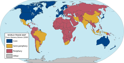
A world map of countries by their supposed trading status in 2000, using the world system differentiation into core countries (blue), semi-periphery countries (yellow) and periphery countries (red). Based on the list in Chase-Dunn, Kawana, and Brewer (2000). World-systems theory (also known as world-systems analysis or the world-systems perspective) is a multidisciplinary approach to world history and social change which emphasizes the world-system (and not nation states) as the primary (but not exclusive) unit of social analysis. World-systems theorists argue that their theory explains the rise and fall of states, income inequality, social unrest, and imperialism.
"World-system" refers to the inter-regional and transnational division of labor, which divides the world into core countries, semi-periphery countries, and periphery countries. Core countries have higher-skill, capital-intensive industries, and the rest of the world has low-skill, labor-intensive industries and extraction of raw materials. This constantly reinforces the dominance of the core countries. This structure is unified by the division of labour. It is a world-economy rooted in a capitalist economy. For a time, certain countries have become the world hegemon; during the last few centuries, as the world-system has extended geographically and intensified economically, this status has passed from the Netherlands, to the United Kingdom and (most recently) to the United States. (Full article...)
World government is the concept of a single political authority with jurisdiction over all of Earth and humanity. It is conceived in a variety of forms, from tyrannical to democratic, which reflects its wide array of proponents and detractors.
A world government with executive, legislative, and judicial functions and an administrative apparatus has never existed. The inception of the United Nations (UN) in the mid-20th century remains the closest approximation to a world government, as it is by far the largest and most powerful international institution. The UN is mostly limited to an advisory role, with the stated purpose of fostering cooperation between existing national governments, rather than exerting authority over them. Nevertheless, the organization is commonly viewed as either a model for, or preliminary step towards, a global government. (Full article...)
Image 3Trilobites first appeared during the Cambrian period and were among the most widespread and diverse groups of Paleozoic organisms. (from History of Earth)
Image 4An animation of the changing density of productive vegetation on land (low in brown; heavy in dark green) and phytoplankton at the ocean surface (low in purple; high in yellow) (from Earth)
Image 18The replicator in virtually all known life is deoxyribonucleic acid. DNA is far more complex than the original replicator and its replication systems are highly elaborate. (from History of Earth)
Image 31Artist's impression of the enormous collision that probably formed the Moon (from History of Earth)
Image 32Artist's impression of a Hadean landscape with the relatively newly formed Moon still looming closely over Earth and both bodies sustaining strong volcanism. (from History of Earth)
Image 37Pangaea was a supercontinent that existed from about 300 to 180 Ma. The outlines of the modern continents and other landmasses are indicated on this map. (from History of Earth)
Image 38Japanese depiction of a Portuguese carrack. European maritime innovations led to proto-globalization.
Image 40An artist's impression of the Archean, the eon after Earth's formation, featuring round stromatolites, which are early oxygen-producing forms of life from billions of years ago. After the Late Heavy Bombardment, Earth's crust had cooled, its water-rich barren surface is marked by continents and volcanoes, with the Moon still orbiting Earth half as far as it is today, appearing 2.8 times larger and producing strong tides. (from Earth)
Image 41Chloroplasts in the cells of a moss (from History of Earth)
Image 42A schematic view of Earth's magnetosphere with solar wind flowing from left to right (from Earth)
Image 44An artist's impression of ice age Earth at glacial maximum. (from History of Earth)
Image 45Earth's western hemisphere showing topography relative to Earth's center instead of to mean sea level, as in common topographic maps (from Earth)
Image 54Geologic map of North America, color-coded by age. From most recent to oldest, age is indicated by yellow, green, blue, and red. The reds and pinks indicate rock from the Archean.
Image 55Tiktaalik, a fish with limb-like fins and a predecessor of tetrapods. Reconstruction from fossils about 375 million years old. (from History of Earth)
Image 56A view of Earth with its global ocean and cloud cover, which dominate Earth's surface and hydrosphere; at Earth's polar regions, its hydrosphere forms larger areas of ice cover. (from Earth)
Image 66Earth's night-side upper atmosphere appearing from the bottom as bands of afterglow illuminating the troposphere in orange with silhouettes of clouds, and the stratosphere in white and blue. Next the mesosphere (pink area) extends to the orange and faintly green line of the lowest airglow, at about one hundred kilometers at the edge of space and the lower edge of the thermosphere (invisible). Continuing with green and red bands of aurorae stretching over several hundred kilometers. (from Earth)
Image 67Artist's impression of Earth during the later Archean, the largely cooled planetary crust and water-rich barren surface, marked by volcanoes and continents, features already roundmicrobialites. The Moon, still orbiting Earth much closer than today and still dominating Earth's sky, produced strong tides. (from History of Earth)
Image 72Exaggerated illustration of Earth's elliptical orbit around the Sun, marking that the orbital extreme points (apoapsis and periapsis) are not the same as the four seasonal extreme points, the equinox and solstice (from Earth)
Image 81The Pantheon, originally a Roman temple, now a Catholic church
Image 82Change in average surface air temperature and drivers for that change. Human activity has caused increased temperatures, with natural forces adding some variability. (from Earth)
Image 90Earth's land use for human agriculture in 2019 (from Earth)
Image 91A 2012 artistic impression of the early Solar System's protoplanetary disk from which Earth and other Solar System bodies were formed (from Earth)
Karachi (/kəˈrɑːtʃi/; Urdu: کراچی; Sindhi: ڪراچي; IPA:[kəˈraːtʃi]ⓘ) is the capital city of the Pakistani province of Sindh. It is the largest city in Pakistan and the 12th largest in the world, with a population of over 20 million. It is situated at the southern tip of the country along the Arabian Sea coast and formerly served as the capital of Pakistan. Ranked as a beta-global city, it is Pakistan's premier industrial and financial centre, with an estimated GDP of over $200 billion (PPP) . Karachi is a metropolitan city and is considered Pakistan's most cosmopolitan city, and among the country's most linguistically, ethnically-, and religiously-diverse regions, as well as one of the country's most progressive and socially liberal cities.
The region has been inhabited for millennia, but the city was formally founded as the fortified village of Kolachi as recently as 1729. The settlement greatly increased in importance with the arrival of the East India Company in the mid-19th century. British administrators embarked on substantial projects to transform the city into a major seaport, and connect it with the extensive railway network of the Indian subcontinent. At the time of Pakistan's independence in 1947, the city was the largest in Sindh with an estimated population of 400,000 people. Afterwards, the city experienced a dramatic shift in population and demography with the arrival of hundreds of thousands of Muslim immigrants (Muhajirs) from India, coupled with a substantial exodus of its Hindu residents. The city experienced rapid economic growth following Pakistan's independence, attracting migrants from throughout the country and other regions in South Asia. According to the 2023 Census of Pakistan, Karachi's total population was 20.3 million. Karachi is one of the world's fastest-growing cities, and has significant communities representing almost every ethnic group in Pakistan. Karachi holds more than two million Bengali immigrants, a million Afghan refugees, and up to 400,000 Rohingyas from Myanmar. (Full article...)
...that in 1819, members of the Catholic Tübingen school first published the Theologische Quartalschrift, which remains in print as the oldest journal of Catholic theology in the world?
Switzerland, officially the Swiss Confederation, is a landlocked country located in west-central Europe. It is bordered by Italy to the south, France to the west, Germany to the north and Austria and Liechtenstein to the east. Switzerland is geographically divided among the Swiss Plateau, the Alps and the Jura; the Alps occupy the greater part of the territory, whereas most of the country's population of 9 million are concentrated on the plateau, which hosts its largest cities and economic centres, including Zürich, Geneva, and Basel.
Within each classification of reserve there may be a variation of IUCN categories Australia is a signatory to the Convention of Biological Diversity and as such has obligations to report the status of its National Reserve System.IUCN provides on its website a prescription for activities consistent with the categorisation system. Changes made to the Nature Conservation Act 2002 in 2014 permit timber harvesting. These changes made in addition to the already established right to access minerals means that many of the IUCN categorisations assigned to individual reserves in Tasmania are no longer fit for purpose. In addition many reserves have had their reserve status downgraded from a class excluding timber harvesting and mineral extraction to ones where these activities are now permitted. This mis-application of the IUCN protected area categories needs to be remedied or the reserves protected land class under the Nature Conservation Act 2002 should be adjusted to reflect its currently assigned IUCN category. (Full article...)
The protected areas of Michigan come in an array of different types and levels of protection. Michigan has five units of the National Park Service system. There are 14 federal wilderness areas; the majority of these are also tribal-designated wildernesses. It has one of the largest state forest systems as well having four national forests. The state maintains a large state park system and there are also regional parks, and county, township and city parks. Still other parks on land and in the Great Lakes are maintained by other governmental bodies. Private protected areas also exist in the state, mainly lands owned by land conservancies. (Full article...)
The Protected areas of Kyrgyzstan are regulated by the law on specially protected natural areas of 2 May 2011, last modified on 2 June 2018. In total, they cover 14,761.216 km2 (5,699.337 sq mi) and account for 7.38% of the country's total area (as of 2017). The first protected area in Kyrgyzstan (Issyk-Kul) was established in 1948. According to the Government Decree on Priorities of Conservation of Biological Diversity and the relevant Action Plan for 2014-2024 the target area for the protected areas in Kyrgyzstan is 10 percent of the country’s area by 2024.
The protected areas are subdivided into seven categories: (Full article...)
West Matukituki Valley and the Matukituki River seen from Cascade Saddle in Mount Aspiring National Park Protected areas of New Zealand are areas that are in some way protected to preserve their environmental, scientific, scenic, historical, cultural or recreational value. There are about 10,000 protected areas, covering about a third of the country. The method and aims of protection vary according to the importance of the resource and whether it is publicly or privately owned.
Image 3Only a few of the largest large igneous provinces appear (coloured dark purple) on this geological map, which depicts crustal geologic provinces as seen in seismic refraction data


 Standing Buddha from Gandhara, 2nd century CE
 The pale orange dot, an artist's impression of the early Earth which might have appeared orange through its hazy methane rich prebiotic second atmosphere. Earth's atmosphere at this stage was somewhat comparable to today's atmosphere of Titan. (from History of Earth)
 Trilobites first appeared during the Cambrian period and were among the most widespread and diverse groups of Paleozoic organisms. (from History of Earth)
 An animation of the changing density of productive vegetation on land (low in brown; heavy in dark green) and phytoplankton at the ocean surface (low in purple; high in yellow) (from Earth)
 Obelisk of Axum, Ethiopia
 Tracy Caldwell Dyson, a NASA astronaut, observing Earth from the Cupola module at the International Space Station on 11 September 2010 (from Earth)
 Earth's history with time-spans of the eons to scale (from History of Earth)
 Artist's rendition of an oxinated fully-frozen Snowball Earth with no remaining liquid surface water. (from History of Earth)
 A view of Earth with different layers of its atmosphere visible: the troposphere with its clouds casting shadows, a band of stratospheric blue sky at the horizon, and a line of green airglow of the lower thermosphere around an altitude of 100 km, at the edge of space (from Earth)
 Chennakesava Temple, Belur, India
 Earth's axial tilt causing different angles of seasonal illumination at different orbital positions around the Sun (from Earth)
 Artist's conception of Hadean Eon Earth, when it was much hotter and inhospitable to all forms of life. (from History of Earth)


 The replicator in virtually all known life is deoxyribonucleic acid. DNA is far more complex than the original replicator and its replication systems are highly elaborate. (from History of Earth)
 Empires of the world in 1898
 A computer-generated image mapping the prevalence of artificial satellites and space debris around Earth in geosynchronous and low Earth orbit (from Earth)
 Ming dynasty section, Great Wall of China
 Angkor Wat temple complex, Cambodia, early 12th century
 A Benin Bronze head from Nigeria
 View of Earth from the Moon by the Lunar Reconnaissance Orbiter (from Earth)
 "Lucy", the first Australopithecus afarensis skeleton found. Lucy was only 1.06 m (3 ft 6 in) tall.
 Graph showing range of estimated partial pressure of atmospheric oxygen through geologic time (from History of Earth)
 A reconstruction of Pannotia (550 Ma). (from History of Earth)
 Artist's impression of the enormous collision that probably formed the Moon (from History of Earth)
 Artist's impression of a Hadean landscape with the relatively newly formed Moon still looming closely over Earth and both bodies sustaining strong volcanism. (from History of Earth)
 Florence, birthplace of the Italian Renaissance
 Dinosaurs were the dominant terrestrial vertebrates throughout most of the Mesozoic (from History of Earth)
 A pillar at Göbekli Tepe
 Pangaea was a supercontinent that existed from about 300 to 180 Ma. The outlines of the modern continents and other landmasses are indicated on this map. (from History of Earth)
 Japanese depiction of a Portuguese carrack. European maritime innovations led to proto-globalization.
 Fall of the Berlin Wall, 1989
 An artist's impression of the Archean, the eon after Earth's formation, featuring round stromatolites, which are early oxygen-producing forms of life from billions of years ago. After the Late Heavy Bombardment, Earth's crust had cooled, its water-rich barren surface is marked by continents and volcanoes, with the Moon still orbiting Earth half as far as it is today, appearing 2.8 times larger and producing strong tides. (from Earth)
 Chloroplasts in the cells of a moss (from History of Earth)
 A schematic view of Earth's magnetosphere with solar wind flowing from left to right (from Earth)
 Yggdrasil, an attempt to reconstruct the Norse world tree which connects the heavens, the world, and the underworld. (from World)
 An artist's impression of ice age Earth at glacial maximum. (from History of Earth)
 Earth's western hemisphere showing topography relative to Earth's center instead of to mean sea level, as in common topographic maps (from Earth)
 Olmec colossal head, now at the Museo de Antropología de Xalapa
 Lithified stromatolites on the shores of Lake Thetis, Western Australia. Archean stromatolites are the first direct fossil traces of life on Earth. (from History of Earth)
 Persepolis, Achaemenid Empire, 6th century BCE
 Battle during the 1281 Mongol invasion of Japan
 Cross-section through a liposome (from History of Earth)
 A map of heat flow from Earth's interior to the surface of Earth's crust, mostly along the oceanic ridges (from Earth)
 Geologic map of North America, color-coded by age. From most recent to oldest, age is indicated by yellow, green, blue, and red. The reds and pinks indicate rock from the Archean.
 Tiktaalik, a fish with limb-like fins and a predecessor of tetrapods. Reconstruction from fossils about 375 million years old. (from History of Earth)
 A view of Earth with its global ocean and cloud cover, which dominate Earth's surface and hydrosphere; at Earth's polar regions, its hydrosphere forms larger areas of ice cover. (from Earth)
 Image of the physical world, captured by the Hubble Space Telescope (from World)
 Taj Mahal, Mughal Empire, India
 First airplane, the Wright Flyer, flew on 17 December 1903.
 Vitruvian Man by Leonardo da Vinci epitomizes the advances in art and science seen during the Renaissance. (from History of Earth)
 Machu Picchu, Inca Empire, Peru
 A composite image of Earth, with its different types of surface discernible: Earth's surface dominating Ocean (blue), Africa with lush (green) to dry (brown) land and Earth's polar ice in the form of Antarctic sea ice (grey) covering the Antarctic or Southern Ocean and the Antarctic ice sheet (white) covering Antarctica. (from Earth)
 An artist's rendering of a protoplanetary disk (from History of Earth)
 Earth's night-side upper atmosphere appearing from the bottom as bands of afterglow illuminating the troposphere in orange with silhouettes of clouds, and the stratosphere in white and blue. Next the mesosphere (pink area) extends to the orange and faintly green line of the lowest airglow, at about one hundred kilometers at the edge of space and the lower edge of the thermosphere (invisible). Continuing with green and red bands of aurorae stretching over several hundred kilometers. (from Earth)
 A 580 million year old fossil of Spriggina floundensi, an animal from the Ediacaran period. Such life forms could have been ancestors to the many new forms that originated in the Cambrian Explosion. (from History of Earth)
 Great Mosque of Kairouan, Tunisia, founded 670 CE
 Great Pyramids of Giza, Egypt


 A reconstruction of human history based on fossil data. (from History of Earth)
 Notre-Dame de Paris, France
 Map of peopling of the world (Southern Dispersal paradigm), in thousands of years ago.
 A banded iron formation from the 3.15 Ga Moodies Group, Barberton Greenstone Belt, South Africa. Red layers represent the times when oxygen was available; gray layers were formed in anoxic circumstances. (from History of Earth)
 A composite image of artificial light emissions at night on a map of Earth (from Earth)
 The Pantheon, originally a Roman temple, now a Catholic church
 Change in average surface air temperature and drivers for that change. Human activity has caused increased temperatures, with natural forces adding some variability. (from Earth)
 Artist's conception of Devonian flora (from History of Earth)
 Ajloun Castle, Jordan
 Shanghai. China urbanized rapidly in the 21st century.
 Last Moon landing: Apollo 17 (1972)
 Satellite time lapse imagery of Earth's rotation showing axis tilt (from Earth)
 Earth's land use for human agriculture in 2019 (from Earth)
 A 2012 artistic impression of the early Solar System's protoplanetary disk from which Earth and other Solar System bodies were formed (from Earth)
.jpeg)


.svg)


.jpg)
.jpg)


.jpg)


.JPG)

.svg)


 The world map by Gerardus Mercator (1569), the first map in the well-known Mercator projection
 Mollweide projection of the world
 Only a few of the largest large igneous provinces appear (coloured dark purple) on this geological map, which depicts crustal geologic provinces as seen in seismic refraction data
 The Goode homolosine projection is a pseudocylindrical, equal-area, composite map projection used for world maps.
 A plate tectonics map with volcano locations indicated with red circles
 Index map from the International Map of the World (1:1,000,000 scale)
 United Nations Human Development Index map by country (2016)
 Time zones of the world
 1516 map of the world by Martin Waldseemüller


 Commons
 Wikibooks
 Wikidata
 Wikinews
 Wikiquote
 Wikisource
 Wikispecies
 Wikiversity
 Wikivoyage
 Wiktionary


